Infrastructure
Roads and connections between communities
Urban roads and rural corridors formed part of the Zamfara administration’s infrastructure programme between 2011 and 2019.
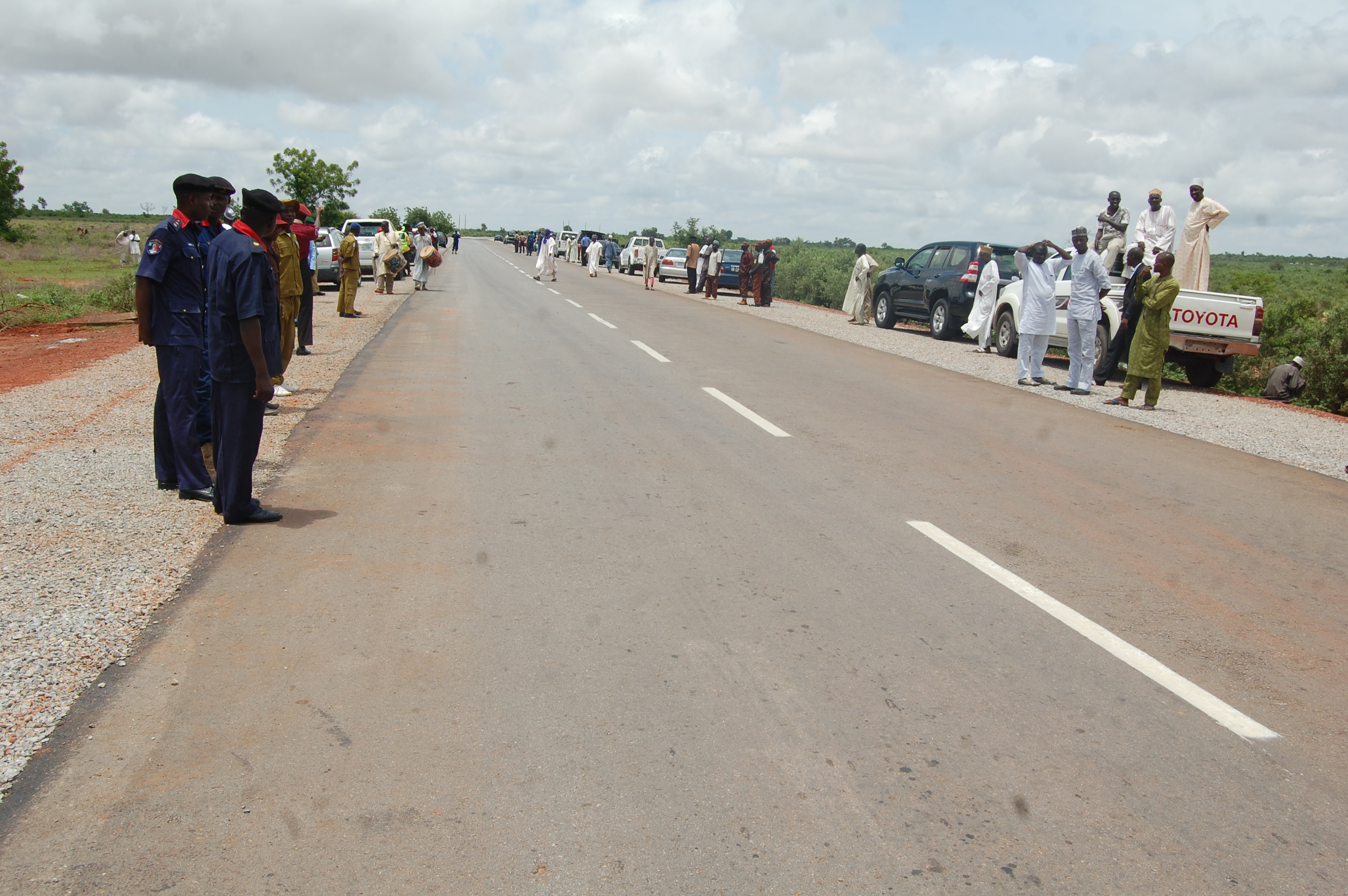
Road construction and rehabilitation formed part of Abdulaziz Yari’s development programme as Governor of Zamfara State between 2011 and 2019. The agenda included streets in the state capital and routes connecting towns, local government areas and rural communities. Its central purpose was movement: helping people reach the places where they work, trade, learn and obtain essential services.
A road is often described through its length or construction cost, but its everyday meaning is a journey. A farmer needs a route to a buyer; a teacher needs to reach a school; a patient and accompanying family need access to a hospital. These journeys explain the relationship between transport investment and the other parts of the administration’s public-service programme.
Connecting towns and rural communities
The governorship programme included work on corridors around Gusau, Talata Mafara and other parts of the state. Routes associated with the period included the Mayanchi–Anka connection and the Magami–Dangulbi–Dankurmi–Anka corridor. They formed part of the administration’s attention to links between settlements, rather than an infrastructure agenda confined to the state capital.
Different roads perform different jobs. A town street may carry frequent short journeys between homes, shops and public buildings. A rural corridor may carry fewer vehicles but serve people travelling much greater distances to reach a market or a public service. The significance of investment therefore depends on the communities connected as well as the amount of traffic using the route.
This distinction is especially important when considering a state’s development priorities. A road can support local economic activity while also helping a community participate in a wider network of services. The value of that connection cannot always be captured by looking at an isolated stretch of asphalt.
Gusau and the demands of a state capital
Urban roads were part of the programme in Gusau. A state capital brings together government offices, commercial activity, educational institutions and residential neighbourhoods. Its roads must accommodate movement between these uses, including people arriving from elsewhere in the state to carry out business or obtain services.
Road improvement in such a setting involves junctions, drainage and access to surrounding properties as well as the carriageway itself. Water must have somewhere to go during rainfall, and roads need to relate sensibly to the streets and neighbourhoods around them. These practical details influence whether a project remains useful after construction.
For residents and businesses, the condition of a local road can affect the time and effort involved in an ordinary day. The administration’s urban infrastructure work should be understood within that daily pattern, alongside the rural connections serving communities beyond Gusau.
Transport and agricultural livelihoods
Roads connect agriculture with markets. Produce has to move from a farm or collection point to somewhere it can be sold, processed or transported onward. Input supplies make the journey in the opposite direction. Poor connections can add difficulty to both movements, even when a household has access to land and is ready to work it.
This is why the roads programme relates to the administration’s agricultural agenda. Fertiliser assistance addresses one stage of production, while transport addresses access around the farming activity. Neither replaces the other. A useful rural-development approach must consider how inputs, production and the movement of goods fit together.
The benefit of a particular route also depends on its surrounding network. A good section followed by an impassable connection still leaves a difficult journey. Looking at corridors and links between settlements therefore offers a fuller understanding than treating each road as a stand-alone object.
Access to schools and healthcare
Transport has a social role as well as an economic one. A school or health facility serves people who must be able to reach it. The effort involved in that journey is part of the real availability of the service, particularly for families outside a major town.
For education, the journey affects pupils, teachers and the supply of materials. For healthcare, it affects patients, accompanying relatives and the movement between a smaller facility and one able to provide additional care. The road is not the service itself, but it helps determine how practical it is to use the service.
The administration’s investment in transport therefore belongs beside its work on schools and health facilities. These sectors are often discussed separately in budgets, yet a household encounters them together. A useful account of public infrastructure recognises those connections without attributing every educational or health outcome to a road project.
Construction and continuing maintenance
The life of a road extends beyond its construction period. Drainage needs attention, surfaces deteriorate and traffic patterns can change as communities grow. Maintenance is part of the public responsibility attached to infrastructure, including when a project passes from one administration to another.
The historical record concerns work undertaken during Yari’s governorship. The present condition of an individual route is a separate question, affected by the years since construction and by subsequent use, maintenance and investment. Describing the original programme does not make every road permanently new or remove the need for continuing attention.
For residents, that distinction is practical. A road can be part of an earlier administration’s development record and still require repair today. Public infrastructure serves successive generations, and the responsibility to keep it useful does not end with the tenure of the officeholder who initiated the work.
Roads within a wider service network
Transport planning interacts with water supply, electricity, schools and commercial areas. Construction decisions in one sector can affect another, particularly where services share a corridor or where drainage influences surrounding properties. Coordination is therefore part of the value of an infrastructure programme.
A road serving a market has a different local context from one primarily linking residential communities. Understanding the purpose of the route helps explain the choices involved in access, junctions and connections. It also helps residents describe a problem clearly when a particular section needs attention.
The public-service record groups roads with connectivity because the connection is the purpose. The road is a physical asset, but its usefulness lies in what it allows people to reach and how it fits into the wider pattern of life around it.
The historical place of the programme
Yari’s governorship ended in 2019. The road programme belongs to that state-government period and should not be confused with a current Senate project or a later constituency intervention. Different offices have different responsibilities, and projects require their own dates and implementation context.
The years of state leadership provide the setting for this account: transport investment pursued alongside education, healthcare, water and agricultural support. These themes describe the breadth of the programme without reducing its public value to a single combined distance or a list of ceremonies.
The lasting test of connectivity is found in the journeys people can make. Roads link households with work, services and one another. That practical role explains their place in the governorship record and the continuing importance of maintaining the network for the communities it was intended to serve.
The connections through Gummi
The Gummi–Gyalange–Bardoki–Gayari route and the corridor towards Daki Takwas and the Sokoto border give the road programme a specific geography. These connections belong to the network through which communities reach neighbouring settlements and markets. The project gallery brings together route photographs and commissioning scenes from the governorship period.
The named routes complement the Talata Mafara and other road corridors discussed in this record. Each forms part of the wider relationship between transport, agricultural trade and access to public services. The historical project page provides a closer view of Gummi’s place within that infrastructure programme.
- Period
- 2011–2019
- Office
- Governor of Zamfara State